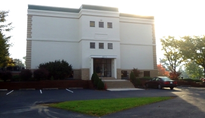
AZTAC's offices are centrally located near all major highways in the Harrisburg area. So regardless of which direction you are coming from, we are not hard to find! When you arrive, enter on either side of the building, and go down about five steps to the 1st floor.
Although our address is Progress Avenue, you must turn on Schoolhouse Lane to enter our parking lot.
Directions from Interstate 81:
AZTAC is approximately 1.5 miles from Interstate 81.
If you are northbound, take Exit # 69 at Progress Avenue, bear to the far right off the ramp, merge onto Progress Avenue.
If you are southbound, take Exit # 69 at Progress Avenue, then turn right at the light onto Progress Avenue.
Go approximately 1.5 miles until you come to a red light at Walnut Street (Route 22).
You will have just passed a Wendy’s on the right.
Go straight at this light, just past the Cricket building on your left, and look for large white building on left.
Turn L on Schoolhouse Lane.
Turn L into the parking lot of the office building, use any available spaces.
Directions from Interstate 83:
AZTAC is approximately 1.1 miles from Interstate 83.
If you are northbound, take Exit 50-B (Jonestown Road). Turn left at the light onto Jonestown Road (Route 22).
If you are southbound, take Exit 50 (Jonestown Road). Go right at the light onto Jonestown Road.
Note: If you are southbound, then you just got off of Interstate 81; Jonestown Road is the first exit on I-83.
Proceed approximately 1.1 miles west on Jonestown Road (Route 22) which soon becomes Walnut Street.
Turn L onto Progress Avenue at the red light.
The Cricket building will be on your left.
Look for large white building on the left (which can be seen from the intersection while you are sitting at the light).
Turn L on Schoolhouse Lane. Turn L into the parking lot of the office building. Use any available spaces.
Directions from Downtown Harrisburg:
AZTAC is 3.0 miles from the Harrisburg Hilton, and 2.5 miles from the Capitol Complex. From Forster Street near the Health and Welfare Building, bear right around the Health and Welfare Building. Get in the left lane and bear to the left which will bring you to a stop sign just before the bridge. Turn left and proceed east on State Street.
From Market Street, turn left on North 5th Street, across the street from the train/bus station, just before the underpass, near the PSERS building. Then turn right on Walnut, stay left, go up the incline and merge onto the State Street Bridge.
State Street will become Walnut Street.
Turn Right onto Progress Avenue at the red light, just past Bitner Funeral Home.
Turn Left onto Schoolhouse Lane, then left into the parking area for 160 S. Progress Avenue.
Directions from PA Turnpike
Take the Harrisburg East exit from the Turnpike, and then follow signs for I-83 NORTH. Follow instructions above.
Directions from PA 283
Take 283 North to I-83 NORTH. Follow instructions above.
Helpful tips
- AZTAC is located very close to the intersection of Walnut Street (Route 22) and Progress Avenue. We are approximately 8 miles from our former location.
- Progress Avenue is a major road that intersects with all of the following: Route 39/Linglestown Road (closer to Route 322 and the river/not near Hershey), I-81, Elmerton Avenue (which connects the Farm Show Building and Colonial Road near Red Lobster), Walnut Street (Route 22), Union Deposit Road, Derry Street, and Paxton Street.
- N. Progress Avenue= S. Progress Avenue = Paxtang Avenue
- Progress Avenue is N. Progress Avenue from Linglestown Road, past I-81, to Walnut Street, then it becomes S. Progress Avenue, and then it changes to Paxtang Avenue before Derry Street.
- Route 22 = Allentown Boulevard = Jonestown Road = Walnut Street = State Street
- Route 22 is Allentown Boulevard east of Harrisburg (our former offices), then becomes Jonestown Road near the Colonial Park area and I-83 interchange, then becomes Walnut Street near the new AZTAC offices, and then becomes State Street within the city limits, taking you straight into the Capitol Complex facing Soldiers Grove and the Capitol Building. State Street then continues again on the other side of the Capitol Building.
- There are exits on I-83 for Paxton Street (Bass Pro Shop), Derry Street, Union Deposit Road and Jonestown Road. If you get off at Jonestown Road, it might be a little easier. If you are traveling on I-83, and you need to get off at Paxton Street, Derry Street, or Union Deposit Road, head west (toward the city) and look for either Paxtang Avenue or Progress Avenue, and turn R. Then stay on that road until you see our office building on the right, just before Walnut Street (Route 22).